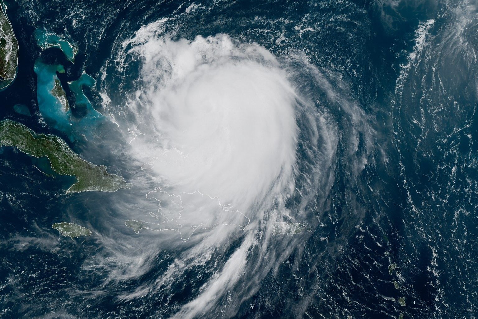
- New Storm Brewing: Tropical Depression Nine (soon-to-be Tropical Storm Imelda) is currently churning through the Bahamas and is forecast to strengthen over the weekend. It is expected to become Hurricane Imelda by early next week as it moves toward the Florida/Carolinas coast 6abc.com apnews.com.
- Major Hurricane Humberto: Meanwhile, Hurricane Humberto is a powerful Atlantic hurricane – with 155 mph sustained winds (Category 4) and rapidly intensifying toward Cat 5 status. It lies roughly 600 miles south of Bermuda, moving west-northwest 6abc.com accuweather.com. Forecasters predict Humberto will remain a “major” hurricane (possibly the second Cat 5 of 2025) heading toward Bermuda and the U.S. East Coast accuweather.com accuweather.com.
- Rare Storm Interaction: Unusually, two tropical cyclones are nearing each other in the Atlantic. Meteorologists warn of a Fujiwhara effect, where the storms could begin to spin around a midpoint accuweather.com apnews.com. If Humberto comes close enough, it could “fling” Imelda northeast and out to sea apnews.com apnews.com – but if it stays distant, Imelda might slow or even linger near the U.S. coast.
- Alerts and Preparations: Both Carolinas are on high alert. Governors in South Carolina and North Carolina have declared emergencies and prepositioned crews for flooding and wind damage. SC Governor Henry McMaster warned the system is “deadly serious,” noting it will bring “high winds” and “a lot of water” 6abc.com 6abc.com. Watches and warnings are already in effect for parts of Florida, the Bahamas and Caribbean islands.
- Flood and Wind Threat: Even without a direct hit, Imelda could stall offshore for days. Forecast models show 2–4 inches of rain from Georgia through Virginia, with 8–16 inches (locally 24 inches) possible across the Carolinas accuweather.com. “Rainfall of this magnitude can lead to widespread life-threatening flooding,” warn AccuWeather forecasters accuweather.com. If Imelda stalls or moves slowly, it could unleash “hours of torrential rainfall” and “life-threatening flash flooding” in the Southeast accuweather.com accuweather.com. Coastal storm surge and dangerous rip currents are also expected along the Southeast seaboard apnews.com accuweather.com.
- Climate and Historical Context: Scientists note that record-warm Atlantic waters are fueling stronger hurricanes with heavier rain climatecentral.org climatecentral.org. Humberto is already only the second Cat 5 storm of 2025 by late September abcnews.go.com. Last year’s Hurricane Helene caused catastrophic flooding in the Appalachians accuweather.com, and forecasters say this new storm could inflict damage comparable to Hurricane Matthew’s 2016 floods if it makes landfall accuweather.com. 2025 was predicted to be an above-normal season (CSU forecast ~16 named storms vs. 14 average) due to warm seas and neutral El Niño conditions tropical.colostate.edu.
Tropical Depression Nine (Imelda) – A Southeast Threat
A tropical disturbance over Cuba and the Bahamas organized into Tropical Depression Nine on Sept. 27. By late Sunday it should become Tropical Storm Imelda 6abc.com. At 8 a.m. ET Sunday it was centered about 285 miles north-west of eastern Cuba and 100 miles WSW of the central Bahamas, moving NNW at 7 mph with 35 mph winds 6abc.com. The National Hurricane Center expects gradual strengthening: Imelda should track north through the Bahamas and then parallel the Florida coast over the weekend abcnews.go.com accuweather.com. A tropical storm watch is already in effect along the east coast of central Florida, and tropical storm warnings cover much of the Bahamas and nearby islands abcnews.go.com 6abc.com.
All eyes are on the projected track. Weather models now suggest Imelda will slow as it nears Georgia/South Carolina and then make a hard eastward turn away from land abcnews.go.com. AccuWeather analysts note that Hurricane Humberto’s circulation could “tug” on Imelda and help steer it out to sea abcnews.go.com accuweather.com. However, timing is critical: as NHC Director Michael Brennan cautioned, “Even if we expect a slowdown and an eastward turn, exactly when that starts and where it happens will make a big difference in how close the center gets to the coastline” apnews.com. If Imelda manages to stall or jog westward, heavy wind and water could reach the coast, but if Humberto’s influence dominates, Imelda may be drawn away apnews.com apnews.com.
Hurricane Humberto – Major Hurricane Eyes Bermuda
At the same time, Hurricane Humberto has ballooned into a major Atlantic hurricane. Satellite and reconnaissance data show Humberto with 155 mph sustained winds (Cat 4) late Sunday 6abc.com. The storm is about 585 miles south of Bermuda and moving WNW at 13 mph 6abc.com. Forecasters say Humberto is likely to briefly weaken to Cat 4 winds but remain a powerful hurricane through early next week, possibly re-strengthening into a Category 5 (its second Cat 5 intensity of 2025) accuweather.com. The current forecast track takes Humberto northward, passing between Bermuda and the U.S. East Coast. AccuWeather forecasts suggest gusty winds and a few inches of rain could reach Bermuda, depending on Humberto’s exact path accuweather.com.
Humberto’s size and strength add uncertainty to Imelda’s path. The two storms are now only several hundred miles apart – a rare configuration not seen in the Atlantic for years accuweather.com. (A somewhat similar situation occurred in 2016 when Hurricanes Matthew and Nicole were about 800 miles apart accuweather.com.) By contrast, in 2021 no two Atlantic hurricanes ever simultaneously existed in close proximity. Meteorologists are actively monitoring how the outer winds of Humberto interact with the new storm. If Humberto weakens or stays far east, Imelda could approach the Southeast coast more directly. If it draws near, Humberto may instead pull Imelda on a loop back out over the Atlantic apnews.com abcnews.go.com.
The Rare Fujiwhara ‘Storm Dance’
Scientists have dubbed the possible interaction a Fujiwhara effect, named after the Japanese meteorologist who first described how two tropical cyclones can orbit each other apnews.com. As USA Today meteorologist Brian McNoldy explains, the storms could “dance together, swirling around a spot in the middle” apnews.com. McNoldy notes this situation is “high impact, high stakes” because both systems are strong. He says most models now suggest Humberto’s circulation is likely to pull the smaller storm eastward and away from the U.S. coast apnews.com. “Not only would it be really neat to watch, but it would fling future Imelda out to sea,” he said apnews.com.
In practical terms, this means that forecasters are issuing a wide range of scenarios. One possibility is that Imelda stalls or parks just off the Southeast coast, as happened with Hurricane Matthew (2016) or inland Appalachian storms, leading to prolonged rain and flooding. Another is that Humberto’s influence forces Imelda on a tight eastward curve – in which case the Carolinas would largely escape direct impact, aside from surf and rip currents. The National Hurricane Center is even flying extra research missions into the area to gather data on how Humberto’s outflow and sinking air might choke off Imelda apnews.com. NOAA Administrator Michael Brennan (NHC) has emphasized that small changes in the track could have big consequences: “[W]e never know where they are going to go,” Governor McMaster echoed 6abc.com.
Preparing for Impact
Authorities are preparing for the worst-case impacts. South Carolina Governor McMaster declared a state of emergency and has positioned search-and-rescue teams. “This storm is deadly serious. Not just serious. Deadly serious,” he said at a press conference 6abc.com. North Carolina Governor Josh Stein has likewise declared an emergency. Charleston, SC, has cleared drains and staged pumps and barricades “out of an abundance of caution” abcnews.go.com. Florida’s east coast is also watching; a tropical storm watch is already up from Volusia County northward.
Meteorologists warn of at least moderate conditions along the entire U.S. Southeast coast, even if Imelda stays offshore. The geometry of the storm and a building Atlantic high pressure will force onshore winds from Georgia through Virginia, creating days of soaked ground and elevated water levels accuweather.com accuweather.com. An AccuWeather analysis paints a grim picture: a 200–400 mile-wide band of 2–4 inches of rain expected from eastern Georgia into Virginia, with 8–16 inches forecast from northeastern South Carolina into eastern North Carolina (local “storm maximums” up to 24 inches) accuweather.com. “If this storm slows down or stalls out, there may be hours of torrential rainfall that could trigger widespread, life-threatening flash flooding,” warned AccuWeather Chief Meteorologist Jonathan Porter accuweather.com. Even inland areas could see serious flooding, as happened last year when Hurricane Helene dumped historic rains on the southern Appalachians accuweather.com.
Coastal residents are advised to prepare for strong winds and dangerous surf regardless of a landfall. Tropical storm conditions (≥39 mph winds) could arrive in parts of Florida by Sunday, and officials note a high risk of rip currents and beach erosion apnews.com accuweather.com. Power outages and minor structural damage are likely if any part of the Southeast is brushed by tropical-storm or hurricane winds accuweather.com. In summary, forecasters urge everyone from Florida through the Carolinas to double-check emergency kits and heed local advisories.
Climate Change & Storm Trends
Experts emphasize that the exceptional intensity of Humberto (already a major hurricane moving into late September) and the heavy rain threat from Imelda fit a broader climate pattern. Oceans have warmed significantly: “Human-caused climate change [has] made waters warmer…fueling more intense hurricanes in the Atlantic,” notes Climate Central climatecentral.org. Warmer seas give storms more energy and moisture, leading to explosive intensification and massive rainfall. In fact, research shows about 80% of Atlantic Category 3–5 hurricanes undergo rapid intensification, and warmer conditions likely increase that fraction climatecentral.org.
2025 has already seen unusually powerful storms: Humberto became Atlantic’s third major hurricane of the season and only its second Cat 5 by late September abcnews.go.com (Hurricanes Erin and Gabrielle were earlier major storms this month). This clustering of intense storms is consistent with forecasts. Colorado State University’s seasonal outlook projected an above-normal season (roughly 16 named storms vs. ~14 climatological average) due to above-normal tropical Atlantic sea-surface temperatures and neutral El Niño conditions tropical.colostate.edu. The rare convergence of Imelda and Humberto illustrates how, in a warmer world, extreme weather events can align in surprising ways.
Historical Comparisons
While unprecedented in recent memory, forecasters point to analogues for this situation. The pairing of Imelda and Humberto has drawn comparisons to Hurricane Matthew & Nicole in 2016, which were spaced similarly in the Atlantic accuweather.com. Last year (2024), the Southeast was walloped by Hurricane Helene’s flooding rains; studies later attributed part of Helene’s extreme rainfall to climate change accuweather.com abcnews.go.com. Imelda’s potential impacts (heavy rain, coastal flooding) could mirror those events if the storm hangs near the coast. Conversely, if the Fujiwhara effect fully kicks in, Florida and the Carolinas might be spared the worst – a situation forecasters find cautiously plausible.
As the situation evolves, experts will be poring over new data (satellite, recon flights, models) day and night. Weather scientist Brian McNoldy summarizes the uncertainty: “It’s not the case that these storms have happened close to the coast and fizzled. These are strong systems – two hurricanes — and this is a high stakes forecast” apnews.com. For now, the southeastern U.S. braces for Imelda while tracking Humberto’s distant menace. Officials urge residents to stay tuned to updates, as “we never know where they are going to go,” Governor McMaster reminded South Carolinians 6abc.com.
Sources: Latest bulletins and analysis from NOAA/NHC and media outlets (ABC News, AP/Guardian, AccuWeather, Climate Central, et al.) 6abc.com accuweather.com climatecentral.org apnews.com.


