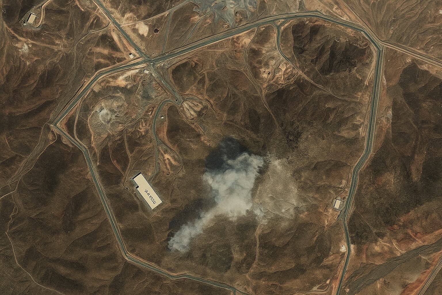
- Satellite photos (from Planet Labs and Maxar) clearly document the Fordow uranium-enrichment site before and after the U.S. strikes foxnews.com cbsnews.com. The post-strike images show wide craters and ash fields on the mountainside above Fordow.
- In the days before the attack, commercial satellites captured unusual activity at Fordow – trucks and bulldozers were seen moving heavy equipment toward the site on June 19–20, 2025 foxnews.com foxnews.com. These images raised alarms that Iran was reinforcing or evacuating the facility.
- The U.S. operation (“Midnight Hammer”) used seven B-2 stealth bombers flying long-range missions, dropping fourteen Massive Ordnance Penetrator (GBU-57) bunker-buster bombs on Fordow and Natanz, plus submarine-launched Tomahawk missiles on Isfahan foxnews.com foxnews.com. U.S. officials called it “the largest B-2 operational strike in US history” 1 .
- The International Atomic Energy Agency reported no increase in off-site radiation levels after the raids foxnews.com. Iran’s nuclear authorities likewise confirmed they had evacuated enriched uranium from these sites ahead of time, preventing any nuclear material release reuters.com 2 .
- Experts agree the satellite pictures show severe damage but caution that only ground inspection can confirm how much of the underground plant was destroyed. FDD analyst Jonathan Schanzer told Fox News “the nuclear program is no longer” after the strikes foxnews.com, while veteran non-proliferation expert David Albright noted there is “no proof yet that the underground halls are pulverized” – they may simply be de-powered or sealed for months 3 .
Before the Strike: Trucks and Bulldozers Spotted at Fordow
Satellite surveillance captured telltale signs of Iranian preparations at Fordow. On June 19, 2025 a Maxar satellite image shows cargo trucks parked outside the underground entrance of the Fordow complex foxnews.com. The next day (June 20) another image reveals bulldozers and heavy vehicles moving toward the tunnel entrance foxnews.com. These vehicles were clearly visible in the raw imagery – Fox News reports that “trucks and vehicles can be seen at the Fordow site” in pre-strike pictures foxnews.com foxnews.com. Open-source analysts say this “unusual activity” likely indicates that Iran was shuffling equipment or shielding the facility just before the U.S. raid.
Satellite imagery on June 20 confirms the buildup: multiple large trucks and earth-moving machines are clustered near Fordow’s hidden tunnel entrance foxnews.com. (This commercial satellite photo from Maxar is a day-old view, before the airstrikes.) Such imagery prompted commentators to note that Iran appeared to be moving assets around Fordow in the final hours before the attack. In fact, Iran’s own state media said vehicles had been evacuated ahead of time reuters.com, and the visual evidence from space supports that narrative.
After the Strike: Massive Craters and Ash Fields
In contrast, after the strikes the satellite photos show the Fordow site reduced to rubble. This Planet Labs/AP image (taken June 22, 2025) shows Fordow’s mountainside aftermath. The U.S. Air Force’s June 21 raid – using 30,000-pound bunker-buster bombs – “obliterated some structures at the site,” according to Pentagon assessments foxnews.com foxnews.com. In the photo above, one can make out blasted openings and debris on the ridgeline above the buried centrifuge halls. Fox News notes the blast “had obliterated some structures” at Fordow foxnews.com, and indeed the image shows large gashes in the rock.
Satellite imagery also reveals ash and collapsed earth. CBS News reports that Maxar images taken immediately after the strike show “a layer of ash” spread across the area, and “several large diameter holes or craters on the top of the ridge” above Fordow cbsnews.com. In other words, the strike left at least three fresh craters roughly 25 meters across ts2.tech. Analysts say these visual signs – subsidence cracks, debris patterns and missing earth – match the effects expected from a Massive Ordnance Penetrator attack on hardened underground tunnels ts2.tech ts2.tech. (By contrast, pre-strike images show none of these scars.)
Operation “Midnight Hammer” Details
According to U.S. officials, the June 21–22 assault (dubbed Operation Midnight Hammer) was meticulously planned. Air Force General Dan Caine called it “the largest B-2 operational strike in US history” foxnews.com. The Pentagon mobilized 125 aircraft, including seven B-2 stealth bombers flying from Whiteman AFB to the target area, along with dozens of fighter escorts, tankers, drones, and even a submarine launching missiles foxnews.com foxnews.com. In total about 75 precision-guided munitions were used foxnews.com. Of these, 14 were 30,000‑lb GBU-57 “Massive Ordnance Penetrator” bombs – the first operational use of this weapon – dropped in pairs on Fordow and Natanz foxnews.com foxnews.com. (Another ~30 Tomahawk cruise missiles struck Isfahan’s uranium-conversion facility on the same night, according to U.S. officials.) The operation employed “advanced deception tactics” to slip the bombers into Iranian airspace undetected 1 .
Despite the intensity, no U.S. losses or shots fired were reported. By Sunday morning, all crews were reportedly safely back. Importantly, Iran’s own nuclear officials and the IAEA said the attack released no detectable radiation outside the sites. The International Atomic Energy Agency tweeted that it had found “no increase in off-site radiation levels” after the Fordow/Natanz/Isfahan strikes foxnews.com ts2.tech. (Iran’s state media likewise claimed the enriched uranium had been moved beforehand reuters.com.) The IAEA’s Rafael Grossi announced an emergency board meeting to assess the situation foxnews.com, but so far the satellite data suggest the radioactive materials remained contained.
Expert Commentary: Iran’s Program “Set Back,” Not Wiped Out
Experts stress that while the images show devastating surface damage, only an on-site assessment can confirm the fate of Fordow’s underground infrastructure. FDD analyst Jonathan Schanzer told Fox News, “The nuclear program is no longer” after the strike foxnews.com, echoing President Trump’s statement that Iran’s enrichment sites were “completely and totally obliterated” foxnews.com. Andrea Stricker (FDD) praised the raid as eliminating “the last vestiges of Iran’s nuclear weapons program,” but cautioned that Iran’s leaders may try to rebuild hidden facilities 4 .
By contrast, other experts urge caution. Dr. David Albright of the Institute for Science and International Security pointed out that the pictures only show surface effects: “There’s no proof yet that the underground halls are pulverized,” he said, noting that loss of power alone could freeze the centrifuges for months ts2.tech. Likewise, King’s College’s Andreas Krieg warned that even “America’s heaviest bunker‑busters” might have trouble reaching Fordow’s deepest chambers ts2.tech. In short, analysts say Iran’s enrichment effort is almost certainly set back (likely by years), but Tehran’s scientific know-how remains intact. Continued intelligence and pressure will be needed to ensure Iran cannot reconstitute its program foxnews.com 3 .
The Role of Satellite Imagery in Modern Conflict
This episode underscores the power of commercial satellite intelligence. Within hours of the attack, high-resolution images from Maxar, Planet Labs and others were circulating online, enabling real-time analysis. In fact, a recent tech report calls satellite imagery “the world’s fastest war correspondent and its most indisputable fact-checker” ts2.tech. News outlets from Fox and CBS to Al Jazeera and Reuters embedded these photos, forcing both U.S. and Iranian officials to respond to hard evidence rather than claims. Analysts and hobbyists quickly compared before-and-after photos (sometimes using Twitter/X and interactive sliders ts2.tech) to verify crater sizes and tunnel collapses. In today’s crises, whoever “controls the pixels” has a big influence on public understanding ts2.tech. In the case of Fordow, satellite OSINT provided the first independent proof of the strike’s impact – days before inspectors could even reach the site.
Sources: Latest news reports from Fox News and CBS News foxnews.com cbsnews.com, Reuters/AFP/Al Jazeera coverage, and expert analysis from think tanks and intelligence sources foxnews.com ts2.tech foxnews.com. These reports rely on commercial satellite imagery (from Planet Labs, Maxar, etc.) to document the attack and its aftermath. All figures and quotes are from official publications or expert interviews.


