- BIOMASS uses a fully polarimetric P-band SAR with a 70 cm wavelength to pierce through canopies and measure woody trunks where most forest carbon is stored.
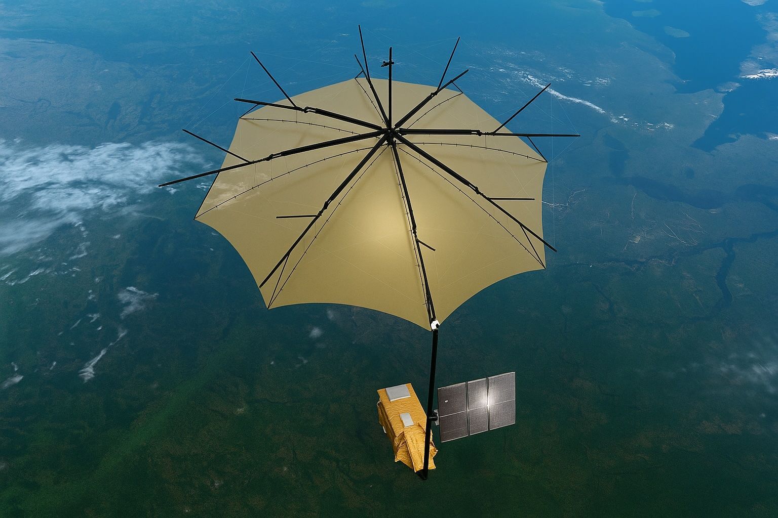
- The 12-meter deployable reflector, shaped like an umbrella and built by L3Harris, directs radar pulses back to the sensor.
- The 1.25-tonne spacecraft was launched on 29 April 2025 aboard a Vega-C rocket from Kourou into a 666 km sun-synchronous orbit (flight VV26).
- The gold-colored reflector unfurled in orbit on 7 May 2025, marking a key commissioning milestone.
- First images show colour-coded maps of the Amazon, Indonesia, and the bedrock of the Sahara.
- By combining three years of global interferometric radar pairs, BIOMASS will generate 3-D maps of forest height and biomass at 200 m resolution, reducing carbon-stock uncertainties by more than 50%.
- Processed data are delivered through ESA’s MAAP cloud platform, enabling scientists to analyze billions of radar echoes without downloading terabytes of raw files.
- The mission’s data will feed into the UNFCCC Global Stocktake and national REDD+ programs to provide an objective yardstick for deforestation pledges.
- BIOMASS can penetrate through canopy and dry desert sand to reveal features such as ancient riverbeds in the Sahara and active volcanic cones beneath Halmahera’s jungle.
- Radio-frequency interference requires blanking transmissions over parts of Europe and North America, with ongoing calibration and a potential five-year extension decision in 2029.
The European Space Agency’s new BIOMASS mission has started to deliver on its dramatic promise: a 12‑metre, umbrella‑shaped radar antenna that peers through dense jungle canopies has sent back its first colour‑coded maps of the Amazon, Indonesia and even the bedrock of the Sahara—offering an unprecedented view of how much carbon the world’s forests really hold, and how fast it is disappearing. phonandroid.com esa.int 1
1. Why Put a Giant “Parasol” in Space?
- BIOMASS is the first satellite to carry a fully‑polarimetric P‑band synthetic‑aperture radar (SAR); its long 70 cm wavelength can slice through leaves and branches to measure the woody trunks where most carbon is stored. esa.int 2
- The deployable 12 m reflector—engineered by L3Harris—is literally shaped like an umbrella and directs the radar pulses back to the sensor. thenextweb.com 3
- Earlier missions such as NASA’s GEDI lidar or ESA’s Sentinel‑1 C‑band SAR see only canopy tops; BIOMASS adds the missing layer, penetrating to the forest floor and even several metres beneath dry desert sand. space.com 3
2. Launch & Engineering Feats
- The 1.25‑tonne spacecraft was launched on 29 April 2025 aboard a Vega‑C rocket from Europe’s spaceport in Kourou, French Guiana, injection into a 666 km sun‑synchronous orbit dubbed flight VV26. newsroom.arianespace.com 4
- Airbus Defence & Space (Stevenage, UK) led spacecraft integration, while European Astrotech fuelled the vehicle before liftoff. 5
- A critical milestone came on 7 May 2025, when the gold‑coloured reflector unfurled flawlessly in orbit—ESA described the deployment video as the moment “the forest satellite’s big antenna opens up.” 3
3. First Images: What the Satellite Saw
| Region observed | Key insights from P‑band radar | Citation |
|---|---|---|
| Bolivia – Rio Beni | Green = primary rainforest; red = flooded forest; blue‑purple = grassland; rivers appear black. | esa.int |
| Halmahera, Indonesia | Radar pierced volcanic slopes, mapping active cones beneath jungle. | esa.int |
| Tibesti Mts., Chad (Sahara) | Signals penetrated up to 5 m of sand, exposing ancient riverbeds. | thenextweb.com esa.int |
| Nimrod Glacier, Antarctica | Long wavelength hints at internal ice layering—useful for ice‑sheet dynamics. | esa.int |
Michael Fehringer, ESA’s project manager, hailed the commissioning results as “nothing short of spectacular…and only a mere glimpse of what is still to come.” 3
4. How BIOMASS Measures Carbon & Climate Feedbacks
- By combining three years of global interferometric radar pairs, the mission will generate 3‑D maps of forest height and biomass at 200 m resolution, reducing current carbon‑stock uncertainties by >50 %. phys.org 3
- Data will feed directly into the UNFCCC Global Stocktake and national REDD+ programmes, giving policymakers an objective yardstick for deforestation pledges. phys.org 6
- Processed datasets are delivered through ESA’s cloud‑based MAAP platform, allowing scientists to analyse billions of radar echoes without downloading terabytes of raw files. 5
5. Expert Reactions
“We need to know the amount of carbon stored in tropical forests. BIOMASS will help us get a better grip on those numbers,”
— Bjorn Rommen, ESA mission scientist 7
“Looking at these first images, it’s clear our Earth‑Explorer satellite is set to deliver a groundbreaking leap in understanding Earth’s forests,”
— Simonetta Cheli, ESA Director of Earth Observation Programmes 3
6. How Does BIOMASS Compare to Its Peers?
| Mission | Sensor | Strength | Limitation |
|---|---|---|---|
| BIOMASS | P‑band SAR | Penetrates canopy & dry sand; global 3‑D biomass | Restricted over N. America & Europe due to radio‑band regulations phys.org |
| NASA GEDI | Lidar | Precise vertical profiles | Limited to ISS orbit, partial spatial coverage |
| NASA‑ISRO NISAR | L‑ & S‑band SAR | Weekly repeat cycles, soil moisture & deformation | Shorter wavelengths—canopy penetration < BIOMASS |
| ICESat‑2 | Green lidar | Ice thickness & canopy height | Cannot image through clouds, sparse ground tracks |
7. Remaining Challenges
- Radio‑frequency interference from ground radars in populated regions means BIOMASS must blank transmissions over parts of Europe and North America, complicating global coverage. 8
- Calibration of the massive reflector and polarimetric channels will continue for several more months; the first quantitative biomass maps are expected in early 2026. 3
- Long‑term mission success also depends on the reliability of the Vega‑C launcher, currently under intense scrutiny after earlier failures unrelated to BIOMASS. 9
8. What Happens Next?
- End‑to‑end Calibration (Q3 2025) – Satellite team will cross‑check radar returns against forest plots in Gabon, Finland and Brazil.
- Release of Level‑2 Data (Q1 2026) – Global biomass density grids and forest‑height models become openly available via MAAP.
- Synergy Campaigns (2026‑2028) – Joint analyses with GEDI, ICESat‑2 and Sentinel‑1 to refine global carbon flux estimates.
- Mission Extension Review (2029) – ESA will decide on a potential five‑year extension based on sensor health and climate‑monitoring priorities. esa.int 10
Key Sources Consulted
- Phonandroid overview of the “umbrella” satellite and first ESA images (French) 11
- ESA press release on first images and mission objectives 12
- Space.com, TNW, Designboom and WoodCentral coverage of inaugural data drops space.com thenextweb.com designboom.com 13
- Phys.org technical explainers on P‑band radar and carbon‑cycle science phys.org phys.org 14
- The Guardian’s pre‑launch interview with mission scientists 7
With its gold “parasol” now unfurled, BIOMASS is on track to become the most powerful tool yet for weighing Earth’s forests from orbit—turning invisible carbon into visible data that could redefine global climate policy.


